Tuesday, August 31, 2010

More Pygmy Rabbits

We went back to the pygmy rabbit site to set up the camera by some burrows that are dug beneath a large metal plate with a tire on top. Not your typical habitat! This time we got photos of cottontails as well as pygmy rabbits, a good comparison! I apologize for the low quality of the scans. The Trailmaster works really well, but it only connects to a film camera!


a cottontail showing off its cottony tail


a cottontail side view


a pygmy rabbit, making sure the trigger goes off


pygmy spaz!

Monday, August 30, 2010

Mapping Aspen Groves

Modern technology can let us do some pretty neat things. Previously, members of our office had hand mapped the locations of aspen groves in the Bodie Hills. Their outlines were then digitized, giving us a decent GIS layer. But with today's software, heads up digitizing can be both more accurate and more precise (remember the difference?). In addition, the availability of imagery gets better all the time. The National Agriculture Imagery Program (NAIP) provides imagery for the entire continental US, and our area was updated in 2009.

I spent some time here and there over the last few weeks updating our layer in order to meet our goal of 1,000 acres of woodland inventory for the year. We can see how areas have declined or improved and identify potential restoration locations. Not field work, but still useful stuff.

Thursday, August 26, 2010

From Your Local Wildlife, With Love

This month, my coworker Casey celebrated the one-year anniversary of his permanent job conversion. What better way to congratulate him than with a contribution from some of the species we manage?

Thank you to the pygmy rabbits, sage-grouse, and mule deer that contributed to our message! And also to Erin for her inspiration. :)

Tuesday, August 24, 2010

Quote of the Month - August

I'm in training in Sacramento all this week, so I won't have any fun field stories or pictures to share. But I will share a text that I received from my friend Gina today. Just another reason that I love being a biologist.
Was pulling forest carnie cams and found chicken full of maggots and somehow thought of you...
How sweet is that?!

Thursday, August 19, 2010

Moth Mystery...Solved!

Today I came across an awesome moth on a basin big sagebrush (Artemisia tridentata ssp. tridentata). I wish I knew more about moths...I seem to always think I'm seeing a tiger moth (family Arctiidae), but they never actually turn out to be one. I wasn't sure if the sagebrush was significant in this case, but it turns out that it was! As far as I can tell (thank you, internets), it's Hemileuca hera (family Saturniidae, wild silk moths), the Hera buckmoth or sagebrush sheep moth. They are indeed active during the day, and I may have disturbed her laying her eggs on the sagebrush. I'm sure she had no problem finding another shrub to lay her eggs on. They'll overwinter and hatch next April-June...and will look like a photo of a caterpillar I had in a previous post! I guess I've come full circle (or is it full life-cycle?) on Hemileuca hera!

Hemileuca hera on Artemisia tridentata ssp. tridentata

I love this orange, fuzzy face!
I believe this caterpillar I previously observed is Hemileuca hera

Wednesday, August 18, 2010

California Greater Sage-grouse Hunt is On

According to Audubon California, the California Fish & Game Commission voted today to allow hunting for Greater Sage-grouse in the North Lassen, North Mono, and South Mono hunting zones. No permits will be given for Central Lassen County. The quota for the Mono zones is 1 per day; 1 per season.

Permit applications were already due to Fish & Game. The general hunting season is September 11 & 12, 2010. The falconry season is November 7, 2010 through January 5, 2011.

Sunday, August 15, 2010

Troubles with Technology

I was super excited to find out that we had a Pettersson bat detector and the corresponding SonoBat software. With it, I can record bat calls and compare them to reference files to find out what bat species are emerging from abandoned mines or using ponds for foraging and drinking. I took it out to another outflight count that Joy and I conducted on thursday evening.


mine entrance with bat gate


detector ready to record

This is how calls of Townsend's big-eared bats (Corynorhinus townsendii) should appear.

This is what I got. Argh!

Apparently the detector was picking up noise when it triggered. It wasn't doing that when I tested it in the office beforehand, so I'll have to see if I can figure out the problem. Never a dull moment!

Wednesday, August 11, 2010

Determining Grazing Use

On tuesday, the grazing dudes showed me how we determine grazing use on the allotments on our land. The permittees are held to certain levels of use on perennial grass species and bitterbrush (Purshia tridentata) to ensure that enough forage remains for native species.


happy ungrazed bitterbrush with leaders of new growth


grazed bitterbrush, clipped with no leaders


grazed Indian ricegrass (Achnatherum hymenoides)

lightly grazed Indian ricegrass with seed heads remaining

ungrazed squirreltail (Elymus elymoides)


native grazer, a mule deer (Odocoileus hemionus) doe

Sunday, August 8, 2010

Bishop Pass

At my coworker Jeff's recommendation, Brent and I braved Bishop Pass for our next backpacking trip. The trailhead is at South Lake at 9800' elevation. The trail gains elevation steadily, reaching Long Lake at 2 miles and 10,750 foot elevation. Traveling along the lake's shore, the trail rises a bit more, passing Spearhead Lake and reaching Saddlerock Lake in another 1.5 miles at an elevation of 11,100'. We set up camp along Saddlerock Lake's shore before braving the Pass. The trail climbs slowly, then suddenly with harsh switchbacks through the granite, reaching Bishop Pass at a lofty 11,972'. This is the crest of the Sierra Nevada, passing from east to west and from the John Muir Wilderness in the Inyo National Forest into Kings Canyon National Park. What an amazing feeling! We dropped down the other side a bit for views into Dusy Basin before retreating from light snow (!) back down to our campsite for the night.

Cool birds of the trip:
  • American Dipper (Cinclus mexicanus) - these amazing birds aren't uncommon in mountain streams, but I still love to see them. They can actually walk along the stream bottom in search of food. They're also known as the Water Ouzel and fittingly, were John Muir's favorite bird.
  • Gray-crowned (Sierra Nevada) Rosy-Finch (Leucosticte tephrosticte dawsoni) - Rosy-finches are only found at high elevations (above 9,500') during the summer. They are possibly the highest breeding bird in North America. It was a treat to see one foraging in the rocks just beyond the Pass.


Bishop Pass Trailhead

back to the wilderness

Epilobium angustifolium
fireweed

Long Lake below Hurd Peak


Saddlerock Lake

juvenile American Dipper
Cinclus mexicanus

I made it!


Dusy Basin


Bishop and Saddlerock Lakes

Gray-crowned (Sierra Nevada) Rosy-Finch
Leucosticte tephrosticte dawsoni

waiting for a pack train to pass

sunset

A few more pictures are available here. Enjoy !

Friday, August 6, 2010

Bat Maternity Colony Outflight Count

On Thursday night, Joy and I were joined by Dr. Pat Brown and her associate to conduct an outflight count of a Townsend's big-eared bat (Corynorhinus townsendii) maternity colony in an abandoned mine. Our western subspecies (C. t. townsendii) is the closest we have to a formally endangered bat in California, although bats are starting to get more attention, particularly since the outbreak of White-Nose Syndrome in the eastern US in 2006. Townsend's big-eared bats were previously considered a Category 2 candidate species by the Fish & Wildlife Service, though the term is no longer in use. They are now considered a Federal Species of Concern, along with a California Species of Special Concern, and BLM Sensitive Species in California. None of those designations packs a whole lot of punch, but at least people are paying some attention. While we do have to close mines to protect human health and safety, we do take the bats into consideration and use bat-friendly structures whenever possible.

To conduct an outflight count, we position ourselves in front of each mine opening. We use an infrared light pointed towards the mine entrance and watch with night vision goggles. I have to say it feels pretty surreal to be up in some random mountains, waiting in silence with black ops gear, but it was one of my coolest experiences on the job so far. I could hear the bats' wings as they flew by my head and out into the night. Between the four of us, we ended up counting over 200 bats flying out. I had 49 from my entrance. At this time of year, this includes the babies as well as the mothers. Dr. Pat says that this is the largest Townsend's maternity colony she knows about in California.

ready to count with my night vision goggles and counter; we use two counters, one for "out" and one for "in"

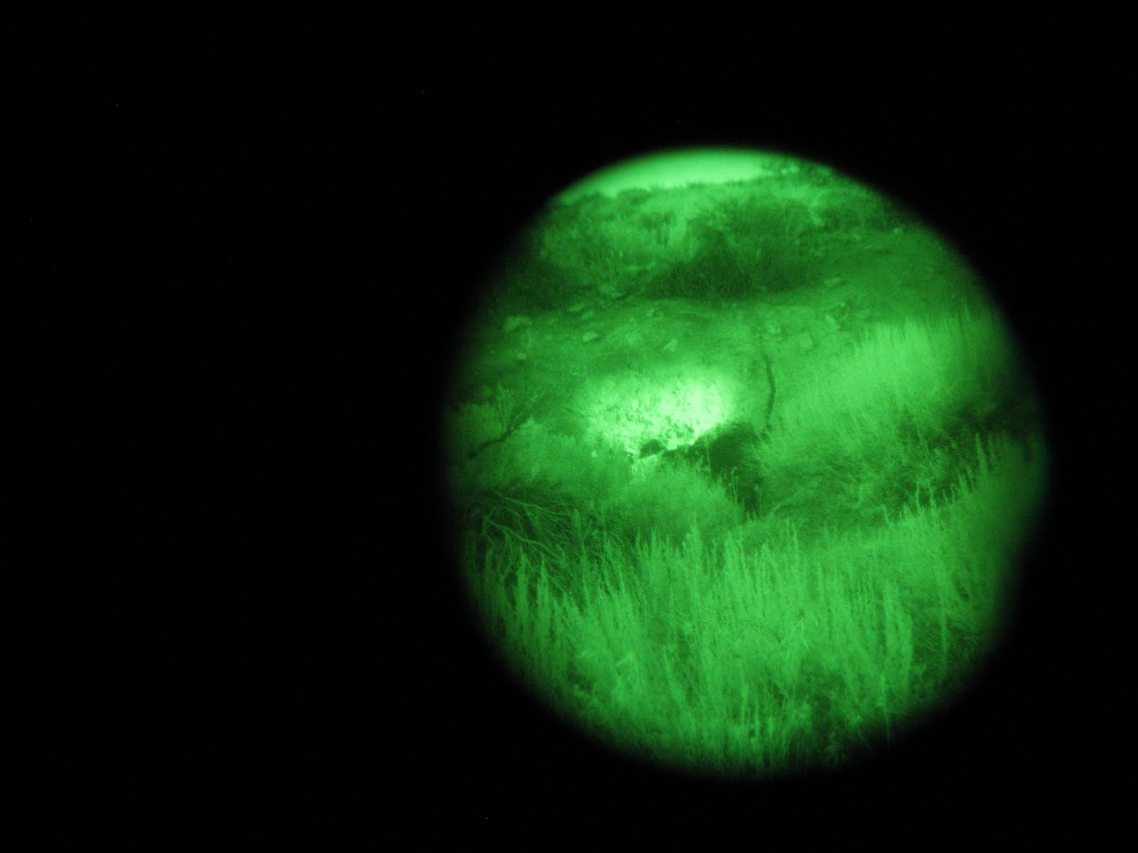
okay picture through one eye of the night vision goggles, showing the infrared light illuminating the mine entrance

Townsend's big-eared bat species account by the Western Bat Working Group (pdf)

Wednesday, August 4, 2010

More Than Poo

Today we went all over the Bodie Hills, looking at various current and prospective projects. It was also my best day for wildlife viewing yet! I wish I had my nice camera, but hopefully these will at least give you a taste:

momma sage-grouse and her brood demonstrating a wildlife-friendly fence along Bodie Creek

mule deer doe
(Odocoileus hemionus)

distant pronghorn antelope (Antilocapra americana)

the group contained 13 females and 1 male
Special thanks to my boss, Steve, for sneaking up on the grouse in our F150 and to Casey for actually taking the shot since I was ensconced in the back seat.

Monday, August 2, 2010

South Tufa, Mono Lake

South Tufa, Mono Lake is just about as alien a landscape as you can get. Tufa towers form when calcium-rich spring water bubbles up through the alkaline lake water and calcium carbonate precipitates out. Normally the towers would be beneath the lake's surface, but due to the lake's lowered elevation (thanks, LADWP), they're visible along the shore. Before water was diverted from the streams filling the lake starting in 1941, the lake's level was at 6417'. In 1982, the lake was at it's lowest elevation, 6372', and had lost 31% of its surface area. That may not seem that low in comparison, but it's the elevation of the lake's level, not simply elevation. Imagine 45 feet of water above your head, covering over 60 square miles in area. In 1994, the California State Water Resources Control Board ruled that Mono Lake should be maintained at a level of 6,391 feet above sea level. When that goal is achieved many of the tufas will return to their underwater domain, but some will remain visible to visitors of South Tufa.


80% of California gulls (Larus californicus) in the state return to Mono Lake every year to breed (not all "seagulls" in California, just the one species). Many of them nested in a huge breeding colony on Negit Island until the lowered lake level exposed a landbridge, allowing predators such as coyotes and raccoons access to an all-you-can-eat omelette bar. Despite attempts to blow up the landbridge with dynamite (that's for you, Michelle), the predators were still able to access the island. Now the gulls nest on smaller islands found within the lake.

The gulls feed on the super abundant brine shrimp (Artemia monica) in the lake's waters and alkali flies (Ephydra hians) found in droves along the shore. Many of them pick their way along the beach, but some have a pretty slick technique that you can watch a bit in this short video.


If you look closely, you can actually see the droves of flies moving out of the way like waves. Tasty !

For more on Mono Lake, visit the Mono Lake Committee.